Some time ago, I wrote an article similar to this one. I used my current location in the UK and Winnipeg in Canada, but I was never happy with that set-up as the locations weren’t exactly the same latitude and the sun could never be said to be over-head (90°).
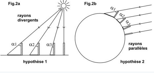
I was reluctant to re-do this effort because I am well aware that different outcomes are achievable when different assumptions are made. For example, if you assume that the earth is a ball and that the sun is 800k miles wide and the rays are parallel, then we can calculate the distance to the sun as 93 million miles.
However, since I can now say that I am able to prove the earth is a flat stationary plane (see my gyroscope experiments) it would no longer be an assumption to use the following “Plane” trigonometry to determine the approximate height of the sun. So I decided it was worth documenting again.
It is understood that:
A right angle triangle has a 90° angle at one of its corners and that all angles of all triangles add up to 180°.
If one of the other angles was 60° then the final angle would be: 180° – (90+60)= 30°
If In another 90° triangle, the second angle is 45° then the 3rd angle must be 45° in order to total 180°
M’kay so far … A 90°+45°+45° Triangle has a special quality, that others don’t, namely the two sides coming away from the 90° corner MUST be equal lengths
So if you know the distance between two places and the angles of observation then you know the distance to the object that both locations are viewing.
This method has been known about for a very long time and was the basis for a trick the old native Americans used to gauge the height of trees etc
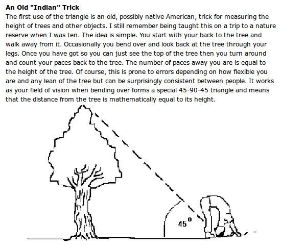
There is no reason why this method of trigonometry would not work on a flat plane to determine the apparent height of celestial objects such as the sun. I say ‘apparent’ height because the atmosphere we view the sun through can add enormous variables in terms of looming, magnifying, refracting, diffracting etc which is beyond the scope of this post.
========================
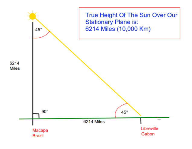
I wanted to choose two locations on the equator that were separated by water, such that when it was 12 o’clock midday in one location with the sun 90° overhead, from the other location the sun would be exactly 45° elevated to the horizon, thus forming the 90° 45° 45° triangle we are looking for.
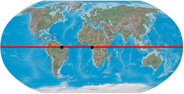
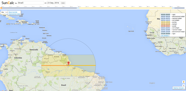
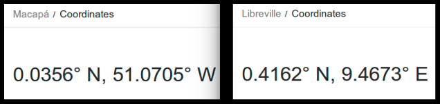
I choose Libreville in Gabon, Africa and Macapá the capital of Amapá state in Brazil.
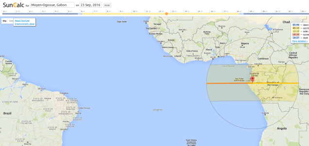
So, as you can see below, the correct angles can be achieved at the end of March/September near the spring/autumn equinox when the sun is travelling directly over and around the equator.
Macapá 90° angle to the sun, midday 23 March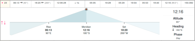
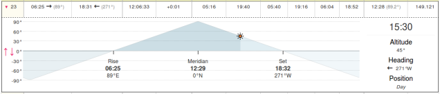
Gabon 45° angle to the sun, 15.30 23 March
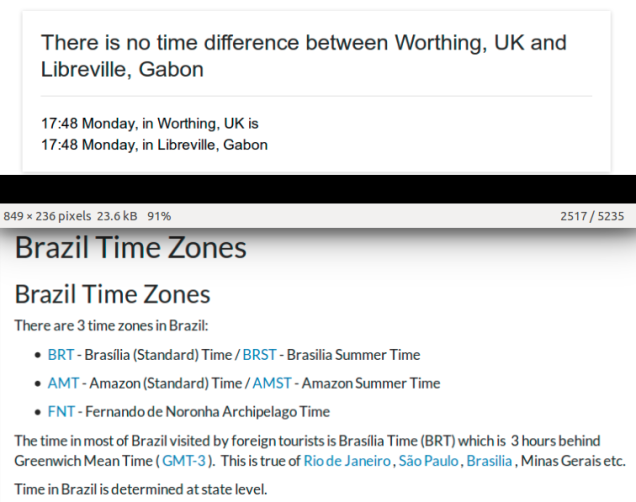
At the time of researching this information, Macapa was GMT-3 hours and Gabon was in line with Greenwich mean time. So best efforts were made to line up the times with the angles, but this is open to refinement, hence why this will be an approximate measurement.
Another reason I choose them was because around the equinox of March and September they are directly under the sun’s path, meaning we can make the all important 90° triangle, far better than at my previous location of 52 degrees North.
Macapa Brazil
Liberville Gabon
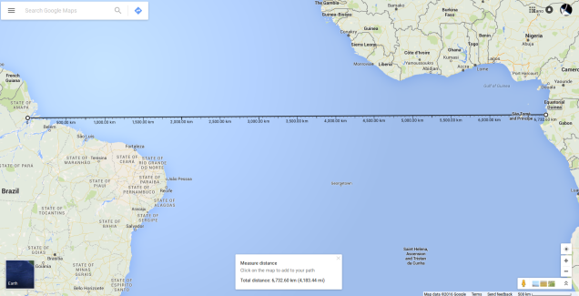
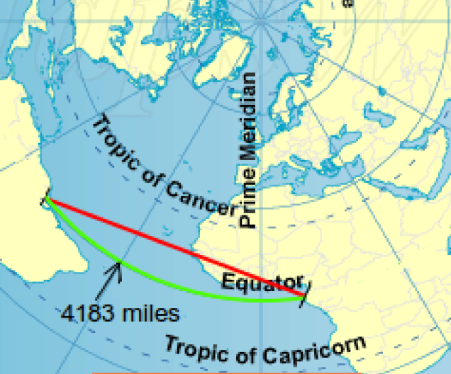
So all we need now is the distance between Libreville and Macapa in order to determine the perceived height of the Sun above the stationary plane of Earth. This is where it got a bit tricky as google maps and google earth measure the rhumb line between any two objects, which translates to a Great Circle route. In this case it would measure around the equator at 4183 miles, but that’s not the straight line distance we are after, plus this distance is based on a ball earth model with an imaginary radius of 3959 miles.
What we are wanting to calculate would be the red line in the diagram below based on the flat plane of Earth, whereas what we are told from google would be the green line based on a ball and as such, inaccurate.
At this point I went off to seek better brains than me (Cheers Adam @larcheored) and we started kicking around how to calculate it.
First we determined the longitudinal bearing of each location from the North Pole, so as to determine the angle between the two locations.
Macapa is 51° West and Libreville is 9° East – giving us a polar angle of 60°. A 60° triangle is an equilateral triangle, and therefore all sides and angles are the same values. Meaning that the distance from the pole to Macapa is equal to the distance between the pole and Libreville, which is also the distance between Libreville and Macapa, and therefore, ultimately the nominal distance from the earth’s surface to the perceived height of the Sun.
So all we need to know now is the distance between the North pole and the equator on the flat Earth.
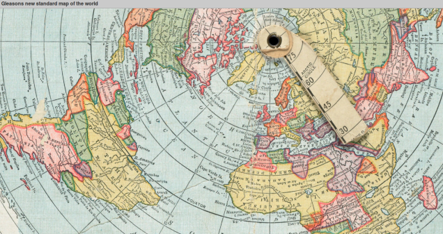
As it happens the ball earth answer to this is the same as the Flat Earth Gleason Map answer
On the ball, we are told that the distance from the Pole to the Equator is:
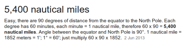
Which is further confirmed by the inscription at the bottom of the Gleason’s Azimuthal Equidistant map
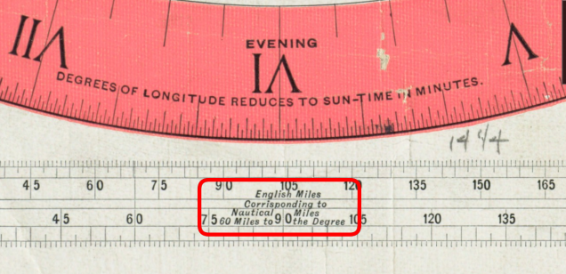
5400 nautical miles (90 degrees x 60 nautical miles) = 6214 Land miles from the Pole to the Equator.
We can note from Gleason’s that roughly 4 lines of longitude lay between Libreville and Macapa (leading to a distance figure of about 4000 miles if we assume the sun travels at 1000mph at the equator, as we are taught)
However, if the radius of Earth’s pole to the equator is actually 6214 miles, this would make the circumference of the equator 39,043 miles, which in turn would mean that the sun’s speed is now more like 1626 mph as opposed to the prescribed 1000mph.
So if sun is travelling at 1626 mph then the distance between Libreville and Macapa would be more like 6507 miles (4×1626), however this would be the arc length (the green line below). Making the cord length between Libreville and Macapa the same as we previously calculated it to be – 6214 miles (According to this cord calculator)
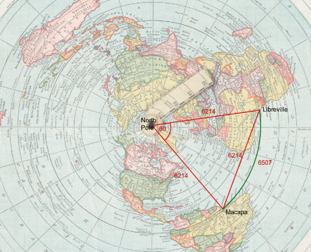
Therefore, this makes the true height of the perceived Sun to be –
6214 miles or 10,000 Kilometres above the stationary plane
Since we can now remove the assumption that the Earth’s a ball, we are finally left with the assumption that modern navigation and Gleason’s measurements are correct (ie. 60 nautical miles to the degree). We cannot confirm this, of course, until we have a reliable map of our world, or we map it out ourselves. I would, however, concede that some things just have to be accurate for aviation, maritime and other industries to function with any degree of dependability …. time will tell.
So in conclusion the following can be argued:

Great! Thanks for your work on this.
LikeLike
Thanks! Just read it and then posted it on Gab. Sure to be a few down votes there. 🙂
Tim
>
LikeLike
Ok, let’s igmore for the moment the Flat Earth claim that at 6000 miles
the atmospheric lensing will make the Sun look like raising or setting.
This work is obviously based on the fact that light from the Sun to the observer goes in straight lines. We will use the same fact in the next example
——————————–
We all know (hopefully) that Sun goes exactly 15 degrees per hour.
Places on same meridian have solar noon at the same moment.
So, we can use speed of solar noon between two places to calculate circumference at their latitude.
Longitudes on Flat and Globe models match.
Latitudes on Flat and Globe model match too.
It means we can ignore any assumptions on the shape of the Earth
until we find the dimensions.
For ground distances we will use values from public records, used in reality for many purposes, commercial / industrial, military, for infrastructures and so on.
Anybody is entitled to provide any other records tested by verifiable measurements or reasonably long general public usage.
Let’s go to Africa, to Equator.
There are Jilib in Somalia, Kampala in Uganda, Mbandaka in Congo, and Libreville in Gabon.
Jilib: longitude – 42.78 degrees east
Kampala: longitude – 32.57 degrees east, distance from Jilib – 1136.5 km
Mbandaka: longitude – 18.29 degrees east, distance from Kampala – 1590 km
Libreville: longitude – 9.47 degrees east, distance from Mbandaka – 981.3 km
From Jilib to Libreville is 3708 km and 33.31 degrees of longitude.
It makes speed of solar noon to be 3708 / 33.31 * 15 = 1669.768 km/h.
That speed multiplied by 24 h gives circumference of Equator to be 40074.45 km
Ofcourse there is error.
Every measurement has errors.
But how big is our error?
Checking Equator circumference at shorter distances inbetween gives
Between Jilib and Kampala we calculate 1669.686 km/h, which gives 40072.48 km.
Between Kampala and Mbandaka we get 1670.168 km/h, giving 40084.03 km.
Between Mbandaka and Libreville we get 1668.877 km/h, which gives 40053.06 km.
All values are very close to each other. Our error is below 0.05% (below 500 ppm – parts per million).
Ok, we do have Equator circumference of 40070 kilometers.
(Give or take kilometer or two.)
Now, let’s go to Australia.
Tropic of Capricorn is at 23.44 degrees south.
I found two places at about 22 degrees south.
Difference is not big, we shall still have pretty low error.
Anyone can find places closer to 23.44 degrees south and test the method personally.
Sandover in Northern Territory: 135.93 degrees east.
Telfer in Western Australia: 122.15 degrees east.
Longitude difference – 13.78 degrees, distance – 1423.22 km.
Speed of solar noon will be 1423.22 / 13.78 * 15 = 1549.22 km/h, which gives circumference of that latitude as 37181 km.
Circumference of the Earth at 22 degrees south is 37181 km.
Two places in India, almost exactly at Tropic of Cancer, 23.4 degrees north.
From Durgapur to Bhuj is 17.61 degrees and 1805 km.
1805 / 17.61 * 15 = 1537.48 km/h, which gives 36899.52 km (36900).
Third number that we wanted to know is circumference of Tropic of Cancer: 36900 km.
Now we have circumferences of the Earth at different latitudes as follows:
23.4 degrees north – 36900 km.
Equator – 40070 km.
22 degrees south – 37181 km.
Would you, please, be so kind to try to scale and fit these measures on flat paper?
Thanks for your patience.
LikeLike